F-35 Lightning II vs Dassault Rafale
- Elite 5K

- Posts: 5999
- Joined: 10 Mar 2006, 01:24
- Location: Nashua NH USA
For what it's worth, not much, I see the possibility that the ECM system can, in that short range bubble, geolocate a transmitting target. The closer the emitter the larger the relative difference in az/el seen by the various antennae. If it can geolocate a ground based emitter at a tactically relevant range then why could it not do so at short range against an air target.
L.Wing antenna says "Emitter Bearing 180.0, Elevation 0.1"
R. Wing antenna says "Emitter Bearing 179.8, Elevation 0.1"
Tail antenna says "Emitter Bearing 179.9, Elevation 0.0"
Just two of those give a precise location, three nails it down more.
I have long thought that between this, the Barracuda, the datalink, and the tens of miles between wingmen the F-35 COULD precisely and passively locate targets at BVR ranges.
"Spurts"
-Pilot
-Aerospace Engineer
-Army Medic
-FMS Systems Engineer
-PFD Systems Engineer
-PATRIOT Systems Engineer
-Pilot
-Aerospace Engineer
-Army Medic
-FMS Systems Engineer
-PFD Systems Engineer
-PATRIOT Systems Engineer
-

- Elite 5K
- Posts: 5733
- Joined: 02 Mar 2017, 14:29
sprstdlyscottsmn wrote:For what it's worth, not much, I see the possibility that the ECM system can, in that short range bubble, geolocate a transmitting target. The closer the emitter the larger the relative difference in az/el seen by the various antennae. If it can geolocate a ground based emitter at a tactically relevant range then why could it not do so at short range against an air target.
L.Wing antenna says "Emitter Bearing 180.0, Elevation 0.1"
R. Wing antenna says "Emitter Bearing 179.8, Elevation 0.1"
Tail antenna says "Emitter Bearing 179.9, Elevation 0.0"
Just two of those give a precise location, three nails it down more.
I have long thought that between this, the Barracuda, the datalink, and the tens of miles between wingmen the F-35 COULD precisely and passively locate targets at BVR ranges.
Although what you say does make some sense there's something else which makes me question the situation above, namely about the picture previously posted or resuming there's something on this posted picture which I find odd:
- The designated target (Mirage 2000) is on cyan. So what is the data/text on top of the SA page that says "287 º/ 50 KT" which is also in cyan?

If the cyan colored data that I mentioned above is in fact the target's (Mirage 2000) heading relative to the Rafale and the 50KT is the "separation speed" between both Rafale and Mirage 2000 than it's strange that SPECTRA can pick up the Mirage 2000 radar emittions since the Mirage 2000 nose/radar cone is emitting away from the Rafale. Schematically it would be something like this:

“Active stealth” is what the ignorant nay sayers call EW and pretend like it’s new.
- Elite 5K
- Posts: 5999
- Joined: 10 Mar 2006, 01:24
- Location: Nashua NH USA
Wind information. Notably, look at the arrow and the associated direction. Winds are displayed with a "from" bearing and the arrow next to it is clearly showing a direction FROM 287, not a HEADING of 287
"Spurts"
-Pilot
-Aerospace Engineer
-Army Medic
-FMS Systems Engineer
-PFD Systems Engineer
-PATRIOT Systems Engineer
-Pilot
-Aerospace Engineer
-Army Medic
-FMS Systems Engineer
-PFD Systems Engineer
-PATRIOT Systems Engineer
-
- Elite 5K
- Posts: 5733
- Joined: 02 Mar 2017, 14:29
sprstdlyscottsmn wrote:Wind information. Notably, look at the arrow and the associated direction. Winds are displayed with a "from" bearing and the arrow next to it is clearly showing a direction FROM 287, not a HEADING of 287
Ok, roger that! Thanks for the info
EDIT: In the sequence of Spudman's post below, can someone confirm if the data in cyan is indeed wind direction&speed or something else (like the target data)?
Last edited by ricnunes on 14 Sep 2017, 12:04, edited 2 times in total.
“Active stealth” is what the ignorant nay sayers call EW and pretend like it’s new.
- Elite 5K
- Posts: 5999
- Joined: 10 Mar 2006, 01:24
- Location: Nashua NH USA
It receives that data from ground stations, but it COULD calculate it itself by differentiating between GPS groundspeed/heading and true airspeed/heading. I have worked programs that incorporate wind information into flight displays.
"Spurts"
-Pilot
-Aerospace Engineer
-Army Medic
-FMS Systems Engineer
-PFD Systems Engineer
-PATRIOT Systems Engineer
-Pilot
-Aerospace Engineer
-Army Medic
-FMS Systems Engineer
-PFD Systems Engineer
-PATRIOT Systems Engineer
- Banned
- Posts: 141
- Joined: 11 Sep 2017, 19:52
sprstdlyscottsmn wrote:For what it's worth, not much, I see the possibility that the ECM system can, in that short range bubble, geolocate a transmitting target. The closer the emitter the larger the relative difference in az/el seen by the various antennae. If it can geolocate a ground based emitter at a tactically relevant range then why could it not do so at short range against an air target.
L.Wing antenna says "Emitter Bearing 180.0, Elevation 0.1"
R. Wing antenna says "Emitter Bearing 179.8, Elevation 0.1"
Tail antenna says "Emitter Bearing 179.9, Elevation 0.0"
Just two of those give a precise location, three nails it down more.
I have long thought that between this, the Barracuda, the datalink, and the tens of miles between wingmen the F-35 COULD precisely and passively locate targets at BVR ranges.
Absolutely. Interestingly, Spectra RWR use interferometry to precisely locate a target emiiting at them. It's highly probable that Barracuda has these passive targeting capabilities (+ C2 platform capabilities F-35 has, but not Rafale).
-

- Elite 2K

- Posts: 2347
- Joined: 27 Mar 2015, 16:05
sprstdlyscottsmn wrote:For what it's worth, not much, I see the possibility that the ECM system can, in that short range bubble, geolocate a transmitting target. The closer the emitter the larger the relative difference in az/el seen by the various antennae. If it can geolocate a ground based emitter at a tactically relevant range then why could it not do so at short range against an air target
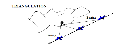
To geolocate ground target with single ship triangulation method, generally aircraft's altitude make up one side of the triangle (because ground radar would be on ground), that cannot be adapted to airborne target because you won't know their altitude without knowing range.
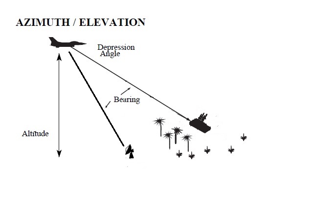
Another way is to to fly aircraft a certain distance to generate bearing differences, because ground radars are stationary. This cannot be used against airborne target for obvious reason
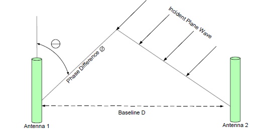
To measure range to target using distance between antenna alone, you need something much more accurate than current interferometry technology.
Example:
distance between antenna: 10 meters
distance to targets: 50.000 meters
-
- Elite 5K
- Posts: 5733
- Joined: 02 Mar 2017, 14:29
cavok wrote:It's highly probable that Barracuda has these passive targeting capabilities (+ C2 platform capabilities F-35 has, but not Rafale).
This is not a matter of "it's highly probably that the Barracuda has passive targeting capabilities", the Barracuda does indeed have passive targeting capabilities as you can see in official manufacturer (BAE systems) datasheet for the AN/ASQ-239 Barracuda which you can download and read from here:
https://www.google.pt/url?sa=t&rct=j&q= ... mVlUjZ0RbQ
In the datasheet/brochure above (and note, this is official manufacturer documentation) you can read the following:
How it works
The AN/ASQ-239 system collects and processes electromagnetic energy to capture a 360-degree aerial field of view to provide a comprehensive picture of the battlespace. This provides the pilot with maximum situational awareness, helping to identify, monitor, analyze, and rapidly respond to potential threats. Using advanced avionics and sensors, the systems takes this a step further by detecting and geo-locating electronic emitters to give pilots the option to evade, engage, counter or jam threats.
“Active stealth” is what the ignorant nay sayers call EW and pretend like it’s new.
-
- Elite 5K
- Posts: 5733
- Joined: 02 Mar 2017, 14:29
Thanks eloise for your throughout explanation about triangulation/geo-location. It indeed makes sense.
One thing that crossed my mind in the case if the situation above where the Rafale could engage a target at "6 o'clock" with a missile in LOAL mode (this case a MICA IR) using "SPECTRA alone" is true and which after reading eloise's post seem to somehow reinforce this idea, is the following:
- SPECTRA will give the heading of the target aircraft (which of course is not "that hard") but it won't give the target's range (see eloise post above) or if it does it gives a very rough approximation of whatever the target's range might be but if the later case is true it certainly won't give a precise range (again see eloise post).
This at least in theory could allow the Rafale pilot/system to launch a missile in LOAL mode (this case MICA IR) into that general heading and in such case the missile (MICA IR) would lock into the first target that its seeker finds in that general heading.
This looks to be a very interesting capability but certainly nothing that remotely resembles the capabilities of the F-35 even because I can see a problem with (Rafale) capability described above:
- Imagine if there are other aircraft in the same general heading or worse even there are friendly aircraft in that heading and again even worse the friendly aircraft is actually a bit closer compared to the enemy/locked target. I guess it's not hard to imagine what would/could happen in such case...
However I must of course admit that such capability is very interesting for "last ditch" and "self-defence" situations!
“Active stealth” is what the ignorant nay sayers call EW and pretend like it’s new.
-
- Elite 5K
- Posts: 5733
- Joined: 02 Mar 2017, 14:29
eloise wrote:ricnunes wrote:passive targeting capabilities
Air to ground passive targeting capabilities is available even on F-4Wild Weasel V with APR-38 and F-16 CJ with ASQ-213
Yes, indeed.
However what the Barracuda brings (integrated in the F-35) is this same capability for non-specialized or resuming for "baseline" variants of the F-35 (All -As, -Bs and -Cs have this capability) and specially internally without the need of any external pods like happened and happens in the cases you mentioned above (APR-38 and ASQ-213).
But in the end you are of course correct and of special interesting note is the APR-38 which while being old technology already had such capabilities...
Last edited by ricnunes on 14 Sep 2017, 12:02, edited 1 time in total.
“Active stealth” is what the ignorant nay sayers call EW and pretend like it’s new.
-
- Elite 2K
- Posts: 2347
- Joined: 27 Mar 2015, 16:05
ricnunes wrote:Thanks eloise for your throughout explanation about triangulation/geo-location. It indeed makes sense
Courtesy of garry mostly
https://basicsaboutaerodynamicsandavion ... olocation/
ricnunes wrote:Yes, indeed.
However what the Barracuda brings (integrated in the F-35) is this same capability for non-specialized or resuming for "baseline" variants of the F-35 (All -As, -Bs and -Cs have this capability) and specially internally with the need of any external pods like happened and happens in the cases you mentioned above (APR-38 and ASQ-213)
Barracuda is much faster and more accurate than HTS and APR-38/47. I recall they said a single F-35 can geo-locate threats faster than 3 F-16CJ, i will try to find the quote
- Elite 5K
- Posts: 5999
- Joined: 10 Mar 2006, 01:24
- Location: Nashua NH USA
The only issue I take with the blanket application of garrya's description is that it assumes you only have one receiver. While what he posts is NOT incorrect, it is also NOT complete. How do your eyes judge distance? by taking two images and referencing the relative difference in position observed by each eye of the same object. In this way with the distributed antennae that all modern aircraft have and sufficient processing capability (the key here) an aircraft could geo-locate any emitter in a snapshot of time given sufficient angular resolution of bearing and elevation.
It's basic geometry.
If you KNOW the relative position of your sensors and each one produces it's own azimuth and elevation to the emitter (granted, here is my assumption, that each antenna has this ability, and I think they do but I cannot prove it) then think if it as shining a laser beam FROM your antenna on said az/el. There will only be one point in space where the beams touch, the target location.
"Spurts"
-Pilot
-Aerospace Engineer
-Army Medic
-FMS Systems Engineer
-PFD Systems Engineer
-PATRIOT Systems Engineer
-Pilot
-Aerospace Engineer
-Army Medic
-FMS Systems Engineer
-PFD Systems Engineer
-PATRIOT Systems Engineer
-
- Elite 2K
- Posts: 2347
- Joined: 27 Mar 2015, 16:05
sprstdlyscottsmn wrote:The only issue I take with the blanket application of garrya's description is that it assumes you only have one receiver.
I think you misunderstood his description, he did assume there are more than one receivers .Accurate direction finding techniques like phase interferometer need a pair of receivers at bare minimum.
sprstdlyscottsmn wrote: How do your eyes judge distance? by taking two images and referencing the relative difference in position observed by each eye of the same object. In this way with the distributed antennae that all modern aircraft have and sufficient processing capability (the key here) an aircraft could geo-locate any emitter in a snapshot of time given sufficient angular resolution of bearing and elevation.
It's basic geometry.
If you KNOW the relative position of your sensors and each one produces it's own azimuth and elevation to the emitter (granted, here is my assumption, that each antenna has this ability, and I think they do but I cannot prove it) then think if it as shining a laser beam FROM your antenna on said az/el. There will only be one point in space where the beams touch, the target location.
What you say about geometry is correct, but the problem is sensor resolution. You need longer baseline than available on the physical area of a single aircraft to provide adequate resolution for the method you proposed. If you look at my table from previous page, you can see that receiver need to be highly accurate, much more than what available. Top ESM like ALQ-218, ALR-94 have angular resolution of around 1-2°
The transmitter aka radar also do not transmit from a point in space.
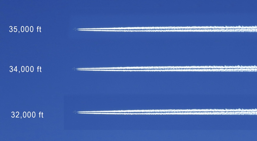
Human eyes are highly accurate sensors with angular accuracy much better than a fighter radar or ELINT, but even them are not so good at judging distance if objects are sufficiently far and you don't know their real size before hand.
Without number on the picture, your eyes cannot tell you which aircraft fly higher. They all look the same to you
Who is online
Users browsing this forum: No registered users and 6 guests